
Understanding Topographic Mapping
Topographic mapping serves as a fundamental tool in understanding and visualising the intricacies of the Earth’s surface. It’s not just about elevations and depressions; these maps also encapsulate the features that define the landscape, from buildings and roads to natural elements like rivers and forests. In the UK, where landscape and development are often intertwined, Topographic mapping plays a crucial role in numerous applications, including planning, construction, and environmental assessments.
What is Topographic Mapping?
A topographic map is a detailed representation of terrain features, providing a three-dimensional perspective through contour lines. These maps illustrate the elevation changes of the land surface and highlight both natural and human-made features. They are essential for architects, engineers, and planners who require precision in their designs and assessments.
History and Evolution of Topographic Maps
The origins of topographic mapping date back centuries when cartographers aimed to represent geographical features accurately. The modern era of topographic maps began in the 19th century with the establishment of national geological surveys. In the UK, the Ordnance Survey played a pivotal role in standardising map-making, developing techniques to capture elevation data accurately and create detailed maps that have evolved with technology.
Types of Topographic Maps Used in the UK
In the UK, various types of topographic maps are employed, each serving specific purposes:
- Military Maps: These maps are tailored for tactical purposes, highlighting strategic features and elevations significant for military operations.
- Tourist Maps: Often used for leisure activities, these maps guide outdoor enthusiasts in hiking and exploring natural landscapes.
- Cadastral Maps: These are focused on land ownership and property boundaries, crucial for legal and planning purposes.
- Urban Plans: Used in city planning, these maps assist in zoning, development projects, and infrastructure planning.
The Importance of Topographic Mapping in Planning
Accurate topographic mapping is essential for effective development. By providing detailed insights into the terrain, these maps facilitate informed decision-making in various fields, including construction, environmental science, and urban planning.
Why Accurate Topography is Critical for Development
Topographic surveys provide critical data for architects and engineers, ensuring that structures are built in harmony with the landscape. An accurate understanding of elevation and terrain helps prevent issues related to drainage, stability, and accessibility. Without a precise topographical survey, projects can face significant delays and costs, making it a non-negotiable aspect of any development plan.
Common Applications in Urban Planning and Infrastructure
In urban planning, topographic maps are integral in designing roads, bridges, and public spaces. They help identify suitable locations for infrastructure, assess the impact of development on the environment, and ensure compliance with local planning regulations. Additionally, these maps aid in disaster management by identifying flood zones and potential landslide areas.
How Topographic Mapping Supports Environmental Assessments
Environmental assessments rely heavily on topographic data to evaluate the impact of development on ecosystems. By understanding the terrain, planners can mitigate adverse effects on wildlife habitats, water systems, and green spaces, ensuring responsible development that aligns with environmental goals.
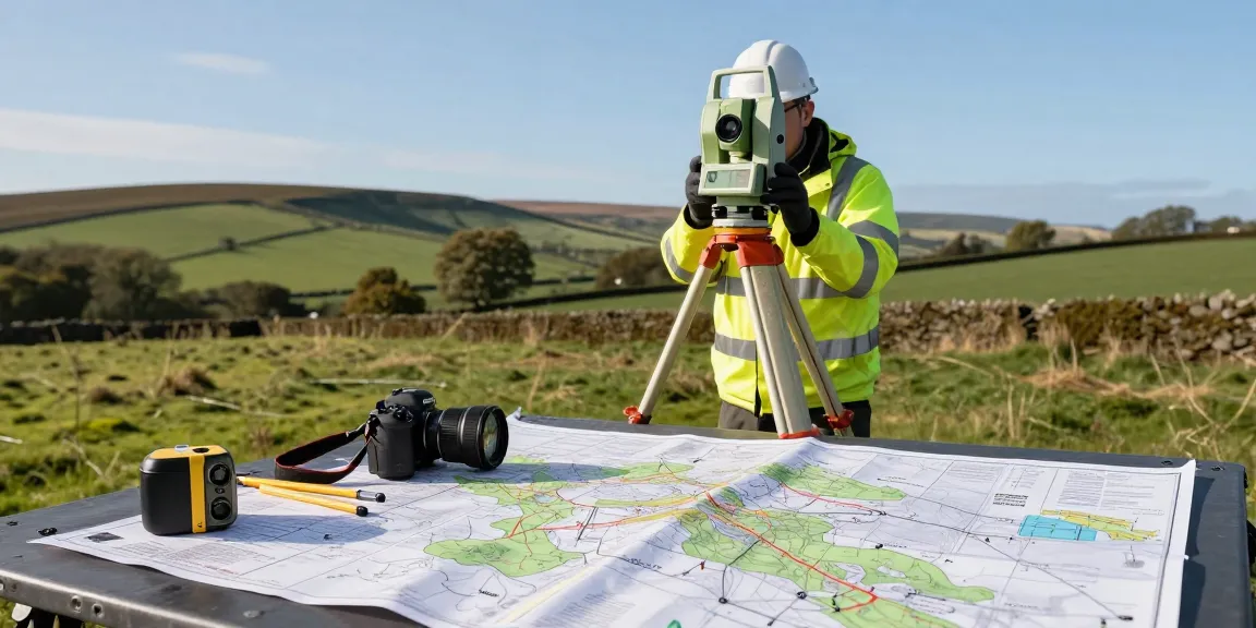
Key Equipment for Topographic Surveying
Modern topographic surveying employs advanced technology that enhances accuracy and efficiency. The following tools are commonly used in the UK to conduct precise topographical surveys.
Modern Technologies Used in Topographic Mapping
Surveyors use a combination of traditional and modern equipment to capture detailed site data:
- Total Station Instruments: These devices combine an electronic theodolite and an EDM, allowing surveyors to measure angles and distances efficiently.
- Global Navigation Satellite Systems (GNSS): GNSS technology is vital for acquiring accurate positional data, especially on expansive rural sites.
- 3D Laser Scanners (LiDAR): This technology measures the distance to a target by illuminating it with laser light, producing accurate 3D models of complex terrains.
- Unmanned Aerial Vehicles (Drones): Drones equipped with high-resolution cameras can survey hard-to-reach areas from above, providing aerial perspectives for comprehensive mapping.
- Digital Level Instruments: These are used for precise height measurements, often in conjunction with contour surveys.
Comparison of Surveying Tools: Advantages and Limitations
While each tool has its unique advantages, there are limitations to consider. Total stations are ideal for small projects but may struggle in expansive areas, while GNSS offers speed but can be less accurate in urban settings due to signal obstruction. Understanding the strengths and weaknesses of each piece of equipment can determine the best approach for any given project.
Best Practices for Selecting Survey Equipment
When selecting survey equipment, consider the project’s nature, the terrain, and the required level of detail. For instance, complex landscapes may benefit from LiDAR technology, while urban settings might require robust GNSS solutions to navigate obstacles. Always assess the specific needs of your project to make the best choice.
Costs and Budgeting for Topographic Surveys
Determining the cost of topographic surveys involves various factors, including the project’s scale and complexity, location, and the technology used. Understanding these elements can help clients budget effectively for their topographic surveying needs.
Understanding Pricing Structures for Topographic Mapping Services
Pricing for topographical surveys can vary significantly. For instance, small residential surveys typically range from £450 to £750, while larger commercial projects can exceed £1,500. It’s essential to obtain fixed-price quotes to avoid any unexpected charges.
Factors Affecting Cost of Topographic Surveys in the UK
Several elements influence the cost of topographic surveys:
- Site Complexity: More complex sites with varying elevations will typically cost more due to the increased time and expertise required.
- Location: Remote or hard-to-access locations may incur additional charges due to travel and logistical considerations.
- Technology Used: The choice of surveying methods (e.g., drones, LiDAR) will impact the overall cost.
- Project Size: Larger projects generally benefit from economies of scale, potentially reducing the per-unit cost.
Budgeting Tips for Land Development Projects
When budgeting for land development projects, consider including a contingency fund to cover unforeseen expenses related to surveying. It’s also advisable to compare multiple quotes from different survey firms to ensure competitive pricing. Lastly, understanding the requirements of local authorities for planning applications can help identify necessary survey elements, potentially streamlining costs.
Future Trends in Topographic Mapping
The field of topographic mapping is evolving rapidly due to technological advancements and changes in industry practices. Staying informed about emerging trends is crucial for professionals in surveying and land development.
Innovative Technologies Shaping the Future of Surveying
Emerging technologies such as artificial intelligence and machine learning are beginning to play a role in processing and analysing survey data. These innovations promise to enhance accuracy and efficiency by automating routine tasks and providing new insights from existing data.
Emerging Trends for 2026 and Beyond in Topographic Mapping
As we look towards 2026 and beyond, we can expect to see an increased integration of real-time data collection through IoT (Internet of Things) devices, allowing for continuously updated topographic data. This shift could revolutionise how planning and developmental decisions are made, offering unprecedented accuracy in monitoring changes to landscapes over time.
Preparing for Changes in Surveying Practices and Regulations
As technology evolves, so too will the standards and regulations governing surveying practices. Keeping abreast of these changes is essential for professionals to remain compliant and competitive in the industry. Regular training and updates from professional bodies can help surveyors adapt to new techniques and legal requirements.
How can topographic mapping benefit construction projects?
Topographic mapping plays a crucial role in construction by ensuring structures are designed according to the landscape’s natural features. Accurate maps help identify potential hazards, assess drainage needs, and optimise site layouts, leading to safer and more efficient construction practices.
What industries rely on topographic maps?
Topographic maps are utilised across various sectors, including construction, urban planning, environmental science, and agriculture. Each of these industries depends on detailed terrain data to inform their decision-making processes, demonstrating the versatility and importance of topographic mapping.
How do I choose a topographic surveyor?
Choosing a topographic surveyor involves evaluating their experience, technology, and understanding of local regulations. Requesting samples of previous work and obtaining client references can provide insights into their capabilities. Always ensure that the surveyor is accredited and insured to guarantee professionalism and reliability.
What is the process of creating a topographic map?
The creation of a topographic map involves several key steps: initial site assessment, selection of surveying tools, data collection, analysis of the gathered data, and the final map drafting. Each step is critical to ensuring accurate and comprehensive mapping of the terrain.
Are there grants available for topographic surveying?
Various grants and funding opportunities may be available for topographic surveying, especially for projects that contribute to environmental sustainability or community development. Researching local and national funding programmes can provide insights into financial assistance options.